Hurricane Florence "since yesterday pulled on to N or NE and converts slowly into an extratropical storm. At best, Newfoundland could still imminent heavy storm, otherwise no land involved. The structure of Florence is already very asymmetrically, and the vortex has been weakened. In Bermuda, there was some damage to roofs of Florence, power lines and on the vegetation, but overall it went quite as lightly. At the airport Kindley Field funds were yesterday morning winds to 106 km / h measured with gusts to 144 km / h. The station in St. David's registered agent winds up to 129 km / h with gusts of 160-180 km / h. The eye of Florence moved about 60 miles (95 km) west past the island, the strongest winds and rains were therefore more Western in open sea.
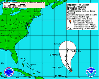
Behind Florence is from the former Tropical Depression No. 7 now, tropical storm "Gordon" has become. This new system is likely tomorrow the strength of a hurricane have reached that represent, according to current calculations, but no threat to land. Only Bermuda could get any sense to some of Gordon.
has the meantime, Further east, formed off the coast of Africa, a new strong tropical wave. This could be later this week to the next hurricane (that would be "Helen") step.
Lars
0 comments:
Post a Comment